Two sets of GIS data are required to enable the Incident Management and Operations in Intterra:
- Nested Shapes
- Fire Stations
These features are included as a part of your department base layers data service (see description below); they are also used to adjust SitStat unit locations in the event a bad coordinate is passed through the AVL table to us. These layers can be useful for Pre-planning and Analytics as well, but are not required to set up these modules.
Source Data Requirements
We require the source data for both sets of data to be submitted in a shapefile, file geodatabase, or as a feature service. If in a file format, please zip these files before you send them since both formats include several files (a shapefile has seven different files and a geodatabase can be upwards of 30 files). We can invite you to drop them in a cloud storage location if the files are too large for email. Please coordinate this sharing of data with your Account Manager. If there are symbology preferences, please include them as layer files (.lyr/.lyrx) or map/project packages.
*Please send all data in GCS_WGS84 (wkid 4326) *
NOTE: Intterra is in the process of transitioning from ArcMap to ArcGIS Pro and can use either to import your data.
Nested Shapes
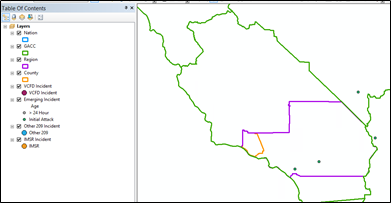
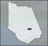
The following polygons are required to build your agency's Briefing Mode, available as part of the Incident Management Module. These shapes generally follow he pattern of: State>Region(s)>County(ies)>City(ies) or Fire District(s). We will only utilize five shapes at max; departments commonly use three of the available slots. We have already pre-loaded a large-level with GACC data, so no need to send us that shape. The below example is from Ventura County Fire Department. You can see they use Region (five county area), and their district boundary. Some State departments use the State Polygon and all Counties in the state. Other metro departments will use their county, then their jurisdiction, then their battalions or response areas as the final shape. As long as the shapes fit within one another, you have some flexibility and can make this tool suit your department's needs.
The below MXD shows the nested polygons (whole polygons that fit inside one another).
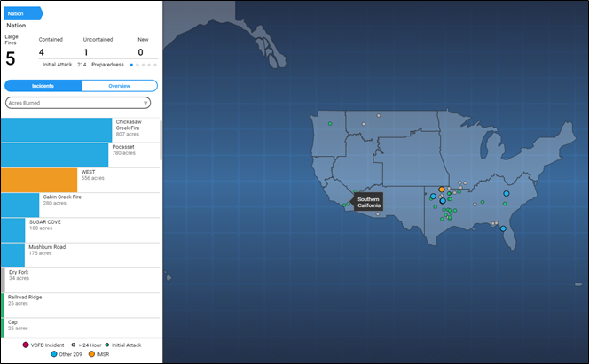
Those shapes then flow into Briefing Mode to create a visualization that:
- Summarizes current incidents across the nation, and
- Focuses your department’s area with your department's SitStat and/or Mapped Incident Data.
Fire Stations
Here we are asking for your fire station data. This is very different from the Stations Lookup table that is required for the Operations and Analytics & Reporting modules - the lookup table needs to match exactly what is coming from your CAD or RMS system and requires very specific data elements. You can find more about lookup tables here: Required: Client Data Lookup Tables
The GIS data we are asking for here is for visualization outside of the Operations module. Station locations are helpful in the Incident Management, Pre-planning, and Analytics & Reporting modules.
Department Base Layers Data Service
We can accept up to ten different data layers to include in this service. These data layers are added with the intention that they will be used for reference for all users in your department, and also visible in all workspaces. Examples can include hydrants, different boundary layers, swift water rescue sites, hospitals, surrounding departments or stations, low water crossings, schools, etc.
These include the non-editable map layers for situational awareness; Intterra pre-configures several for your agency, however, local/regional/state data may be desired as well. These data layers will only be updated once per year.
This service is available with all modules.
External Services/Web Services
You have the option to request placement of any additional web services to which your department has access within your application configuration, as long as they are HTTPS. We can also handle credentialed services, assuming the credentials do not expire (or only do so annually). We suggest starting with no more than 15 additional web services in any given workspace.
The following are possible OGC-compliant web service types (listed in the order of ease for loading):
- ArcGIS Rest Service (URL from Server or AGOL)
- WMS/WFS (Open Source Web Map Service)
- KML/KMZ
FYI: External Map Services are read-only in Intterra; External Feature Services are editable in Intterra (this delineation is noted at the end of the URL). Services from AGOL will always have a FeatureServer endpoint (unless they are tiled) but our system looks at if editing has been enabled on the service. Click ArcGIS Online Group Sharing from Client to Intterra for more information.
NOTE: For external services, we cannot scale performance on services that we do not host. If you find that an external service loads too slowly or drags down performance of the system while turned on, we will recommend removing it from your system.